Skip to main content
College Algebra
My Course
Learn
Exam Prep
AI Tutor
Study Guides
Textbook Solutions
Flashcards
Explore
Try the app
My Course
Learn
Exam Prep
AI Tutor
Study Guides
Textbook Solutions
Flashcards
Explore
Try the app
Back
Graphs and Coordinates definitions
6 students found this helpful
You can tap to flip the card.
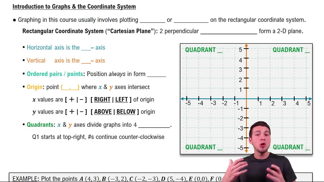
Rectangular Coordinate System
You can tap to flip the card.
👆
Rectangular Coordinate System
A two-dimensional grid formed by intersecting perpendicular number lines, used to locate points with two values.
Track progress
Control buttons has been changed to "navigation" mode.
1/15
Related flashcards
Related practice
Recommended videos
Graphs and Coordinates quiz
Graphs and Coordinates
15 Terms
Graphs and Coordinates
2. Graphs of Equations
6 problems
Topic
Callie
Two-Variable Equations
2. Graphs of Equations
5 problems
Topic
Callie
2. Graphs of Equations
3 topics
8 problems
Chapter
Callie
Guided course
02:16
Graphs and Coordinates - Example
4492
views
359
rank
2
comments
Guided course
05:10
Graphs & the Rectangular Coordinate System
8586
views
266
rank
4
comments
Terms in this set (15)
Hide definitions
Rectangular Coordinate System
A two-dimensional grid formed by intersecting perpendicular number lines, used to locate points with two values.
Cartesian Plane
A plane defined by a horizontal and a vertical axis intersecting at a central point, allowing for graphical representation of pairs.
X-Axis
The horizontal reference line in a coordinate system, used to determine the first value in an ordered pair.
Y-Axis
The vertical reference line in a coordinate system, used to determine the second value in an ordered pair.
Origin
The intersection point of the horizontal and vertical axes, serving as the central reference with coordinates (0,0).
Ordered Pair
A set of two numbers in parentheses, indicating a specific location on a two-dimensional grid.
Coordinate
A numerical value representing a position along either the horizontal or vertical axis in a plane.
Quadrant
One of four regions created by the intersection of the axes, each labeled and used to describe point locations.
Grid
A network of intersecting lines forming squares, used as a background for plotting points in two dimensions.
Intersection
The point where the horizontal and vertical axes cross, dividing the plane into four regions.
Positive Value
A number greater than zero, indicating movement to the right or upward from the central reference point.
Negative Value
A number less than zero, indicating movement to the left or downward from the central reference point.
Two-Dimensional Plane
A flat surface defined by two axes, allowing for the representation of locations using pairs of numbers.
Number Line
A straight line with evenly spaced values, used as a reference for measuring positions along an axis.
Reference Point
A fixed location, typically the intersection of axes, from which positions are measured in a coordinate system.
 BackBack

 02:16
02:16