Skip to main content
Intermediate Algebra
My Course
Learn
AI Tutor
Study Guides
Flashcards
Explore
Try the app
My Course
Learn
AI Tutor
Study Guides
Flashcards
Explore
Try the app
Back
The Rectangular Coordinate System definitions
You can tap to flip the card.
Rectangular Coordinate System
You can tap to flip the card.
👆
Rectangular Coordinate System
A two-dimensional grid formed by perpendicular horizontal and vertical number lines, used to plot locations with two values.
Track progress
Control buttons has been changed to "navigation" mode.
1/15
Related flashcards
Recommended videos
The Rectangular Coordinate System quiz
The Rectangular Coordinate System
15 Terms
Guided course
02:16
Graphs & the Rectangular Coordinate System Example 1
177
views
6
rank
05:09
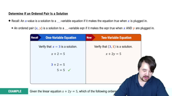
Determining Whether an Ordered Pair is a Solution to an Equation
172
views
6
rank
02:44
Graphs & the Rectangular Coordinate System Example 2
139
views
4
rank
Terms in this set (15)
Hide definitions
Rectangular Coordinate System
A two-dimensional grid formed by perpendicular horizontal and vertical number lines, used to plot locations with two values.
Cartesian Plane
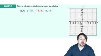
A diagram with intersecting x and y axes, dividing space into four regions for plotting points with ordered pairs.
X Axis
The horizontal number line in a two-dimensional grid, representing the first value in an ordered pair.
Y Axis
The vertical number line in a two-dimensional grid, representing the second value in an ordered pair.
Origin
The intersection point of the x and y axes, located at 0,0, serving as the reference for all coordinates.
Ordered Pair
A set of two numbers in parentheses, indicating a specific location on a grid using x and y values.
Quadrant
One of four regions created by the x and y axes, each with distinct combinations of positive and negative values.
Linear Equation
An algebraic expression involving two variables, whose solutions are points that satisfy the relationship when substituted.
Solution
A set of values for variables that makes an equation true when substituted, often represented as an ordered pair.
Coordinate
A numerical value indicating position along an axis, used in pairs to specify locations on a grid.
Table
A structured arrangement of values for variables, used to organize and complete ordered pair solutions.
Standard Form
A way of writing equations with variables and constants arranged in a specific order, aiding in analysis and graphing.
Coefficient
A numerical factor multiplying a variable in an equation, influencing the slope or steepness of a line.
Degree
The highest exponent of a variable in a polynomial, indicating the complexity of the equation.
Intersection
The point where two axes cross, dividing the plane into four regions and serving as the reference for coordinates.
 BackBack
 02:16
02:16