 Indietro
Spatial Criminology and the Production of Crime in South Africa
Guida di studio - Note intelligenti
 Appunti personalizzati basati sui tuoi materiali, ampliati con definizioni chiave, esempi e contesto.
Spatial Criminology: Theories and South African Context
Introduction to Spatial Criminology
Spatial criminology explores how crime is distributed across different places and times, emphasizing that crime is not random but clusters in specific locations. Understanding the spatial patterns of crime helps explain why certain areas experience higher crime rates than others.
Key Point: Crime clusters in particular neighborhoods due to their spatial and economic characteristics.
Example: Johannesburg's Hillbrow (high crime) vs. Sandton (low crime) demonstrates spatial and economic influences on crime rates.
The Chicago School and Human Ecology
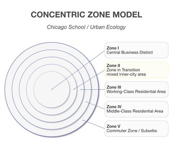
The Chicago School, developed by Park and Burgess in the 1920s, conceptualizes the city as a living organism that grows in concentric zones, each with unique social and physical features. This model helps explain the spatial distribution of crime and social problems.
Key Concept: Transitional zones experience the highest social disruption and crime due to constant population turnover.
The Five Concentric Zones:
Zone 1: Central Business District (CBD) – commercial and financial core.
Zone 2: Zone of Transition – mixed-use, deteriorating housing, home to low-income residents and immigrants.
Zone 3: Working-Class Residential Zone – stable homes for blue-collar workers.
Zone 4: Middle-Class Residential Zone – larger homes, professionals, better infrastructure.
Zone 5: Commuter Zone – suburbs/exurbs, wealthier residents commuting to the city.
Social Disorganization Theory
Social disorganization theory posits that high crime rates in certain neighborhoods are due to weak community structures and environmental conditions, not individual failings. Shaw and McKay (1942) found persistent crime in specific areas regardless of the ethnic group residing there.
Key Indicators: Poverty, residential mobility, and ethnic heterogeneity weaken social controls.
Example: Informal settlements in South Africa, such as Diepsloot, experience high crime due to weak formal and informal social controls.
Environmental Criminology
Environmental criminology focuses on the immediate context of crime, shifting attention from why individuals offend to how environments create opportunities for crime. It emphasizes modifying physical spaces to reduce crime opportunities.
Five Components of a Crime Event: Space, time, law, offender, and target/victim.
Core Idea: Changing the environment can prevent crime without altering human nature.
Routine Activity Theory
Routine Activity Theory (Cohen & Felson, 1979) states that crime occurs when three elements converge in time and space: a motivated offender, a suitable target, and the absence of a capable guardian. This is often visualized as the Crime Triangle.
Example: South African public transit hubs, such as Bree Street taxi rank, are high-risk areas for pickpocketing due to dense crowds and limited guardianship.
Crime Pattern Theory
Crime Pattern Theory (Brantingham & Brantingham) explains that crime occurs where offenders' awareness spaces overlap with the paths of suitable targets, especially at 'edges'—boundaries between different land uses or neighborhoods.
Example: The M1 highway in Johannesburg creates high-risk buffer zones for property crime at intersections near affluent suburbs.
Defensible Space and CPTED
Oscar Newman's Defensible Space theory (1972) argues that architectural design can empower residents to control their environments. Crime Prevention Through Environmental Design (CPTED) builds on this by using design, lighting, and landscaping to deter crime.
Four Elements of Defensible Space: Territoriality, natural surveillance, image, and milieu.
CPTED Pillars: Access control, surveillance, territorial reinforcement, and maintenance.
Example: Poor CPTED in South African townships like Khayelitsha leads to high crime due to unlit paths and lack of surveillance.
Apartheid Spatial Planning and Its Legacy
The Group Areas Act of 1950 enforced racial segregation, pushing non-white populations to city peripheries and creating enduring spatial inequalities. Buffer zones (industrial areas, railways) were used to separate racial groups, resulting in vacant, crime-prone lands.
Example: Open fields between Mitchells Plain and industrial areas are now dangerous transit zones.
Spatial Entrapment and Transport Crime
Long commutes from peripheral townships to city centers increase exposure to crime, especially on vulnerable public transit routes.
Example: Metrorail lines in the Western Cape are sites of frequent robberies and vandalism.
Gated Communities and Urban Enclaving
Wealthy South Africans respond to crime by creating gated communities and fortified suburbs, leading to 'fortress cities.' This often displaces crime to adjacent, less protected neighborhoods and increases social fragmentation.
Example: Steyn City and Dainfern Golf Estate contrast sharply with neighboring informal settlements.
Crime Displacement vs. Diffusion of Benefits
Crime prevention in one area can either displace crime to another (displacement) or reduce crime in surrounding areas as well (diffusion of benefits).
Example: Fortifying one suburb may push property crime into the next un-gated neighborhood.
Urban Decay and Broken Windows Theory
Broken Windows Theory (Kelling & Wilson, 1982) suggests that visible disorder (e.g., broken windows, graffiti) signals neglect, inviting more serious crime. This leads to fear and withdrawal, weakening informal social control.
Example: Hijacked buildings in Johannesburg's CBD become hubs for criminal activity.
The Geography of Gangsterism
Gangs thrive in high-density, impoverished areas with clear territorial boundaries. Spatial isolation reinforces gang control and identity.
Example: The Cape Flats, with its high-density tenement blocks, is a stronghold for gangs.
Hot Spots Policing and Spatial Surveillance
Hot spots policing focuses law enforcement on micro-locations with high crime rates. Spatial surveillance, such as CCTV, is used to monitor and reclaim public spaces, though it raises concerns about profiling and privacy.
Example: Cape Town's CBD uses extensive CCTV networks to reduce street crime.
Private Security and the Spatial Divide
South Africa's large private security industry means safety is often tied to spatial location and income. High-income areas have rapid armed response, while low-income areas rely on under-resourced police.
Spatial Justice and Urban Redesign
Achieving sustainable crime reduction requires addressing spatial inequalities by integrating affordable housing into economic hubs and ensuring equitable distribution of resources and opportunities—known as spatial justice.
Innovative Spatial Interventions
Projects like the Violence Prevention through Urban Upgrading (VPUU) in Khayelitsha use urban design (e.g., high-mast lighting, community centers) to increase safety and natural surveillance in informal settlements.
Summary of Key Themes
Space actively shapes criminal opportunities.
South African crime is deeply tied to historical spatial segregation.
Defensive architecture can displace risks onto vulnerable populations.
Sustainable crime prevention requires structural spatial justice, not just physical barriers.
