 뒤로
Ecological Principles and Biomes: Study Guide for General Biology
스터디 가이드 - 스마트 노트
 자료에 맞춘 맞춤형 노트, 핵심 정의, 예시, 맥락을 확장해 제공합니다.
Ecological Principles
Ecology: Definition and Levels of Study
Ecology is the scientific study of how organisms interact with both biotic (living) and abiotic (non-living) factors in their environment. The term derives from the Greek 'oikos' (house) and 'logia' (study). Ecological studies can be conducted at several hierarchical levels:
Organism: Focuses on individual organisms and their immediate environment.
Population: Examines groups of individuals of the same species within a local habitat.
Community: Studies interacting populations of different species within a specific geographic area.
Ecosystem: Considers interacting communities and their abiotic environment.
Biosphere: Encompasses all ecosystems globally.
Abiotic Factors
Abiotic factors are non-living components that influence ecosystems. Key abiotic factors include:
Atmospheric Conditions: Weather and climate, including temperature, precipitation, humidity, wind direction, and speed.
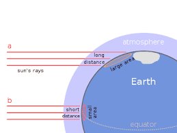
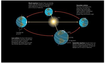
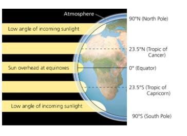
Seasonality: Latitude affects photoperiod, temperature, and precipitation patterns.
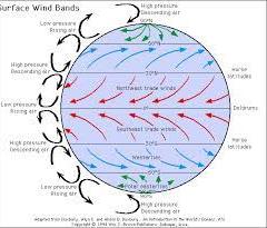
Global Air Circulation: Driven by solar energy and Earth's rotation, affecting climate and weather patterns.
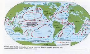
Global Ocean Currents: Influenced by continental positions, water temperature, and density.
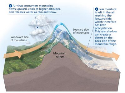
Topography: Variation in elevation affects water flow, precipitation, temperature, pressure, light penetration, and oxygen concentration.
Seasonality
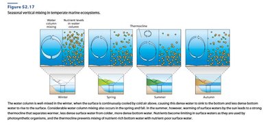
Seasonality refers to the predictable changes in environmental conditions throughout the year, primarily caused by Earth's tilt and orbit around the sun. This affects temperature, photoperiod, and precipitation patterns.
Global Air Circulation
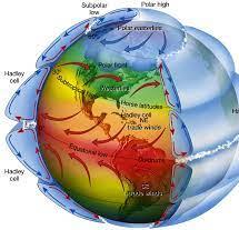
Solar energy drives global air circulation patterns. As the sun heats the tropics, hot moist air rises, expands, cools, and releases water as precipitation. Cooler, drier air moves toward the poles. Earth's rotation affects the direction and speed of air masses, creating distinct wind bands.
Air masses moving toward the equator are deflected west.
Air masses moving toward the poles are deflected east.
Global Ocean Currents
Ocean currents are driven by prevailing winds and are deflected by continents. Water's high heat capacity moderates climate, carrying warm or cold water between poles and equator.
Surface currents influence regional climates.
Warm and cold currents affect coastal temperatures.
Topography
Topography refers to the variation in elevation of Earth's surface.
Mountains: Temperature decreases with elevation; rain shadow effects create differences in precipitation and vegetation.
Valleys: Heat is trapped, increasing temperature.
Aquatic: Water depth affects pressure, light penetration, and water movement.
Effects of Vegetation on Climate
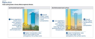
Vegetation influences regional climate by affecting temperature and precipitation.
Forested areas absorb more solar radiation, fueling photosynthesis and transpiration, leading to cooler temperatures and higher precipitation.
Deforested areas absorb less solar radiation, resulting in warmer temperatures and lower precipitation.
Climate Change
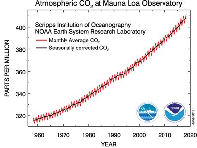
Climate change refers to long-term shifts in temperature and weather patterns, often driven by increased atmospheric CO2 and other greenhouse gases.
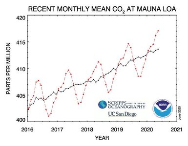
CO2 levels have risen steadily since the 1960s, correlating with global warming.
Seasonal fluctuations in CO2 are observed, but the overall trend is upward.
Biomes
Definition and Types of Biomes
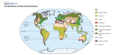
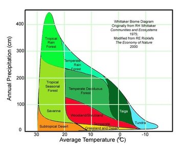
A biome is a distinct physical environment inhabited by ecologically similar organisms with similar adaptations. Convergent evolution is common in biomes, where unrelated species develop similar traits due to similar environmental pressures. Terrestrial biomes are generally determined by temperature and precipitation, which influence vegetation type.
Aquatic Biomes: Freshwater (lakes, rivers), Marine (oceans, coral reefs, estuaries)
Desert Biomes: Hot & dry, semi-arid, coastal, cold
Grasslands: Savannas (tropical), temperate
Tundra: Arctic, alpine
Forests: Tropical, temperate, boreal
Temperate Deciduous Forest
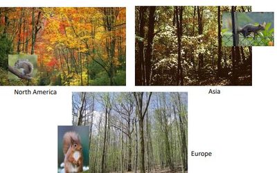
Temperate deciduous forests are characterized by moderate temperatures and precipitation, with trees that lose their leaves seasonally. These forests are found in North America, Europe, and Asia, and support diverse animal and plant life.
Adaptations include seasonal leaf loss and hibernation in animals.
Examples: Squirrels, deer, and various deciduous trees.
Aquatic Biomes
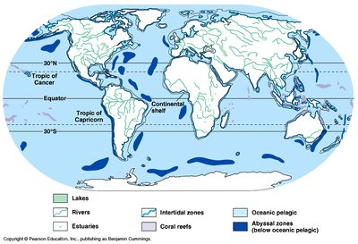
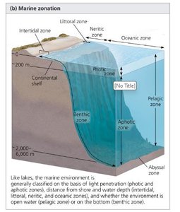
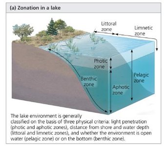
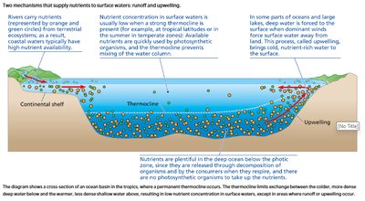
Aquatic biomes are classified based on salinity, depth, and light penetration.
Freshwater: Lakes, rivers
Marine: Oceans, coral reefs, estuaries
Zonation: Photic (light), aphotic (no light), benthic (bottom), pelagic (open water)
Dispersal & Distribution
Factors Affecting Distribution
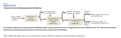
The distribution of organisms is influenced by both biotic and abiotic factors.
Biotic Factors: Predation, competition, disease
Abiotic Factors: Temperature, water, oxygen, salinity, sunlight, rocks, soil
Walter Climate Diagrams
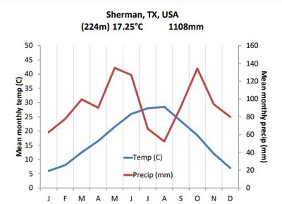
Walter climate diagrams are used to visualize the relationship between temperature and precipitation throughout the year for a given location. These diagrams help identify periods of drought and humid conditions, and are useful for comparing climates across biomes. 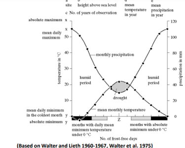
Summary Table: Major Terrestrial Biomes
Biome | Temperature | Precipitation | Vegetation | Example Location |
|---|---|---|---|---|
Tropical Rain Forest | High | High | Dense, diverse trees | Amazon Basin |
Desert | High/Low | Low | Sparse, drought-resistant | Sahara |
Temperate Deciduous Forest | Moderate | Moderate | Deciduous trees | Eastern US |
Taiga (Boreal Forest) | Low | Moderate | Coniferous trees | Canada, Russia |
Tundra | Very Low | Low | Mosses, lichens | Arctic |
Savanna | High | Moderate | Grasses, scattered trees | Africa |
Key Equations
Photosynthesis (Relevant to Vegetation and Climate)
Population Growth (Relevant to Ecology)
Logistic Growth (Relevant to Population Ecology)
Conclusion
Understanding ecological principles and biomes is fundamental to General Biology. These concepts explain how organisms interact with their environment and how abiotic factors shape the distribution and adaptation of life on Earth. Study these diagrams and tables to reinforce your understanding of ecological systems and their global patterns.
