Ch.12 - Parametric and Polar Curves
Briggs - Calculus: Early Transcendentals 3rd Edition
Briggs3rd EditionCalculus: Early TranscendentalsISBN: 9780136847243당신이 사용하는 게 아니라요?교과서 변경
12장, 문제 12.2.24

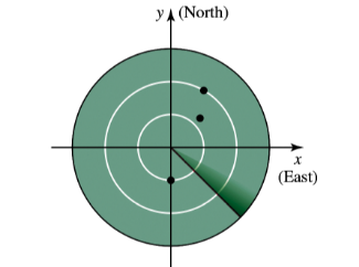
23–24. Radar Airplanes are equipped with transponders that allow air traffic controllers to see their locations on radar screens. Radar gives the distance of the plane from the radar station (located at the origin) and the angular position of the plane, typically measured in degrees clockwise from north.
img
A plane is 50 miles from a radar station at an angle of 10 dgeree clockwise from north. Find polar coordinates for the location of the plane.

검증된 단계별 안내
1
Understand the problem setup: The radar station is at the origin (0,0), and the plane's position is given by a distance (radius) and an angle measured clockwise from the north (y-axis).
Identify the given values: The plane is 50 miles from the radar station, and the angle is 10 degrees clockwise from north.
Convert the angle from clockwise from north to the standard polar coordinate angle, which is measured counterclockwise from the positive x-axis (east). Since the angle is 10 degrees clockwise from north, the equivalent angle in standard polar coordinates is \(\theta = 90^\circ - 10^\circ = 80^\circ\).
Express the polar coordinates of the plane as \((r, \theta)\), where \(r\) is the distance from the origin and \(\theta\) is the angle in standard polar form. Here, \(r = 50\) miles and \(\theta = 80^\circ\).
If needed, convert the polar coordinates to Cartesian coordinates using the formulas: \(x = r \cos(\theta)\) and \(y = r \sin(\theta)\), where \(\theta\) is in degrees or radians as appropriate.

비슷한 문제에 대한 검증된 영상 답변:

이 영상 해법은 위 문제에 도움이 된다고 튜터들이 추천한 것입니다.
영상 길이:
4m
도움이 되었나요?

주요 개념

질문에 올바르게 답하기 위해 반드시 이해해야 하는 핵심 개념들은 다음과 같습니다.

Polar Coordinates

Polar coordinates represent a point in the plane using a distance from the origin (radius) and an angle measured from a reference direction, typically the positive x-axis. In this problem, the plane's location is given by its distance from the radar station and an angle measured clockwise from north, which can be converted to standard polar coordinates.
추천 영상:
05:32
Intro to Polar Coordinates

Angle Measurement and Conversion

Angles in polar coordinates are usually measured counterclockwise from the positive x-axis (East). Since the problem gives the angle clockwise from North (positive y-axis), it is essential to convert this angle to the standard polar angle by adjusting the reference direction and direction of measurement.
추천 영상:
8:22
Trig Values in Quadrants II, III, & IV Example 2

Relationship Between Cartesian and Polar Coordinates

Polar coordinates (r, θ) can be converted to Cartesian coordinates (x, y) using x = r cos θ and y = r sin θ. Understanding this relationship helps visualize the plane's position on the coordinate plane and interpret the radar data in terms of standard coordinate systems.
추천 영상:
05:32
Intro to Polar Coordinates