 Back
Back1.3 Biomes and the Biosphere: Structure, Climate, and Distribution
Study Guide - Smart Notes
 Tailored notes based on your materials, expanded with key definitions, examples, and context.
The Biosphere and Biomes
Definition and Scope
The biosphere encompasses all living organisms on Earth and the environments in which they reside. Within the biosphere, biomes are major terrestrial communities defined by their climate, soil, and disturbance patterns. Each biome supports characteristic plant and animal life adapted to its specific conditions.
Biosphere: The global sum of all ecosystems, including land, water, and atmosphere where life exists.
Biome: A large ecological area on the Earth's surface with distinct climate, flora, and fauna (e.g., tropical rainforest, desert, tundra).
Biomes are shaped by temperature, precipitation, soil type, and disturbance regimes (such as fire or grazing).
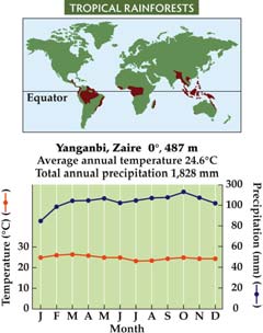
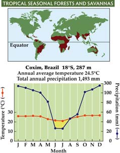
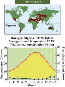
Climate and Biome Distribution
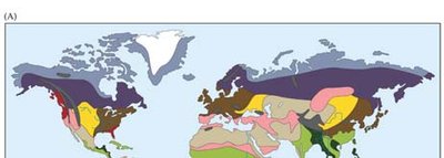
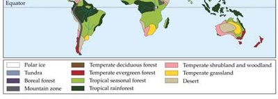
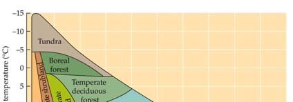
Biomes are distributed globally according to patterns of temperature and precipitation. Climate diagrams and maps help visualize these relationships and the geographic extent of each biome.
Temperature and precipitation are the primary factors determining biome type.
Climate diagrams plot mean annual temperature against mean annual precipitation to show where biomes occur.
Major Terrestrial Biomes
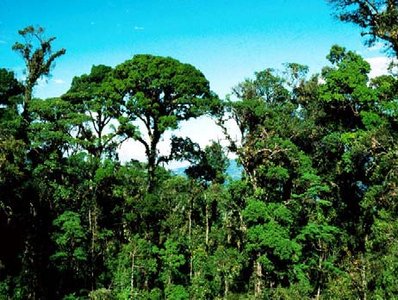
Tropical Rainforests
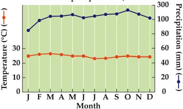
Tropical rainforests are found near the equator (between 10ºN and 10ºS) and are characterized by high temperatures, abundant rainfall, and intense competition for light. These forests are among the most biodiverse ecosystems on Earth.
Warm temperatures and high precipitation year-round.
Little seasonal variation; plants grow continuously.
Contain about 50% of Earth's species.
Soils are typically nutrient-poor due to rapid decomposition and leaching.
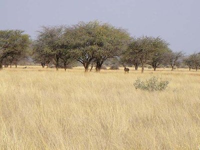
Tropical Seasonal Forests and Savannas
Located between 10º and 23.5º latitude, these biomes experience pronounced wet and dry seasons. Vegetation includes more grasses and shrubs than rainforests, with trees often being deciduous. Fire and grazing are important ecological factors.
Seasonality of water is the key factor.
More open canopy than rainforests; frequent fires and grazing maintain the landscape.
Soils are generally more fertile than in rainforests.
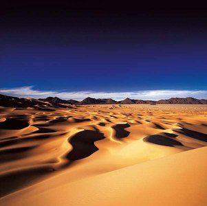
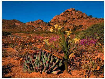
Deserts (Hot and Cold)
Deserts are found around 30º latitude north and south and are defined by low precipitation. They can be hot or cold, but all experience water scarcity. Plant and animal life is adapted to extreme conditions.
Low precipitation and either high (hot deserts) or seasonally low (cold deserts) temperatures.
Soils have low organic matter; plant cover is sparse or absent.
Biodiversity can be high, but overall abundance is low.
Organisms exhibit behavioral and physiological adaptations to conserve water.
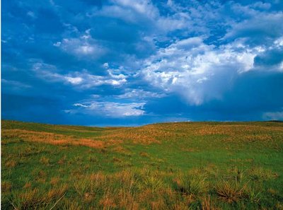
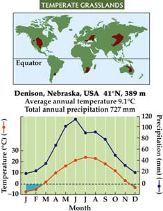
Temperate Grasslands
Temperate grasslands are found between 30º and 50º latitude and are maintained by fire and grazing. They experience warm, moist summers and cold, dry winters. These regions are often used for agriculture due to their fertile soils.
Fire and grazing prevent tree establishment and maintain grass dominance.
High soil fertility supports crops and livestock.
Seasonal temperature and precipitation patterns.
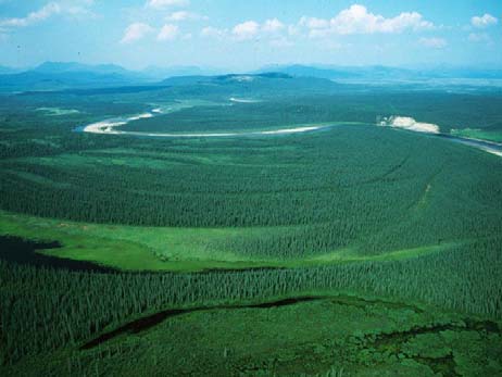
Boreal Forests (Taiga)
Boreal forests are located above 50ºN latitude and are dominated by coniferous trees. They experience long, severe winters with subfreezing temperatures and permafrost in the soil.
Key factor: severe winters and short growing seasons.
Soils often freeze (permafrost), limiting decomposition and nutrient cycling.
Vegetation: primarily conifers such as spruce, fir, and pine.
Tundra
The tundra biome is found above 65ºN latitude and is characterized by extremely cold temperatures, low precipitation, and permafrost. Vegetation is limited to low-growing shrubs, grasses, mosses, and lichens.
Key factors: cold temperature, low precipitation, and permafrost.
Short growing season; low biodiversity.
Distinct from cold deserts due to latitude and presence of permafrost.
Summary Table: Major Terrestrial Biomes
Biome | Latitude | Key Climate Factors | Dominant Vegetation | Soil Fertility |
|---|---|---|---|---|
Tropical Rainforest | 10ºN–10ºS | High temp, high precipitation | Broadleaf evergreen trees | Poor |
Tropical Seasonal Forest/Savanna | 10–23.5ºN&S | Seasonal rainfall | Deciduous trees, grasses | Moderate |
Desert | ~30ºN&S | Low precipitation | Sparse shrubs, succulents | Low |
Temperate Grassland | 30–50ºN&S | Seasonal temp, fire, grazing | Grasses | High |
Boreal Forest | >50ºN | Cold, subfreezing winters | Conifers | Low–moderate |
Tundra | >65ºN | Very cold, low precipitation | Mosses, lichens, low shrubs | Low |
Additional info:
Disturbance regimes such as fire and grazing play a critical role in maintaining certain biomes (e.g., grasslands, savannas).
Human activities, including agriculture and logging, have significantly altered many biomes, reducing biodiversity and changing ecosystem functions.
