 Back
Back1.3 Biomes and the Biosphere: Structure, Climate, and Distribution
Study Guide - Smart Notes
 Tailored notes based on your materials, expanded with key definitions, examples, and context.
The Biosphere and Biomes
Definition and Scope
The biosphere encompasses all living organisms on Earth and the environments in which they reside. Within the biosphere, biomes are major terrestrial communities defined by their climate, soil, and disturbance patterns. Each biome supports characteristic plant and animal communities adapted to its specific conditions.
Biosphere: The global sum of all ecosystems, including land, water, and atmosphere where life exists.
Biome: A large ecological area on the Earth's surface with distinct climate, flora, and fauna.
Biomes are shaped by temperature, precipitation, soil type, and disturbance regimes (e.g., fire, grazing).
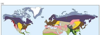
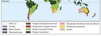
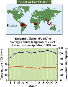
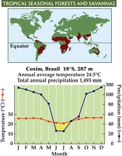
Climate and Biome Distribution
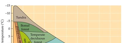
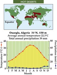
Biomes are distributed according to global patterns of temperature and precipitation. Climate diagrams and maps help visualize how these factors influence biome locations.
Temperature and precipitation are the primary determinants of biome type.
Climate diagrams plot mean annual temperature against mean annual precipitation to show where different biomes occur.
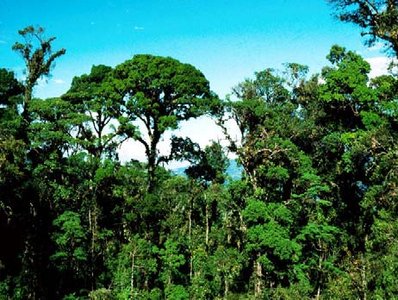
Tropical Rainforests
Characteristics and Distribution
Tropical rainforests are found between 10ºN and 10ºS latitude. They are characterized by high biodiversity, intense competition for light, and consistently warm, wet conditions throughout the year.
High annual precipitation (often >200 cm/year) and little seasonal variation in temperature.
Soils are typically nutrient-poor due to rapid decomposition and leaching.
Contain about 50% of Earth's species, making them biodiversity hotspots.
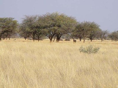
Tropical Seasonal Forests and Savannas
Characteristics and Distribution
Tropical seasonal forests and savannas are found between 10º and 23.5º latitude north and south of the equator. These biomes are defined by pronounced wet and dry seasons, with water availability as the key limiting factor.
Vegetation includes more shrubs and grasses than rainforests, with fewer trees.
Trees are often deciduous, shedding leaves during dry periods.
Fire and grazing are important ecological processes that maintain the structure of these biomes.
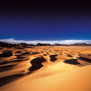
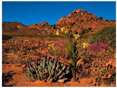
Deserts (Hot and Cold)
Characteristics and Distribution
Deserts are found around 30º latitude north and south. They are defined by low water availability, with hot deserts experiencing high temperatures and cold deserts having cold winters. Both types have low precipitation.
Soils have low organic matter and are often sandy or rocky.
Plant cover is sparse to absent; animal abundance is low, but biodiversity can be high due to specialized adaptations.
Organisms exhibit behavioral and physiological adaptations to conserve water.
Human intrusion is increasing, impacting desert ecosystems.
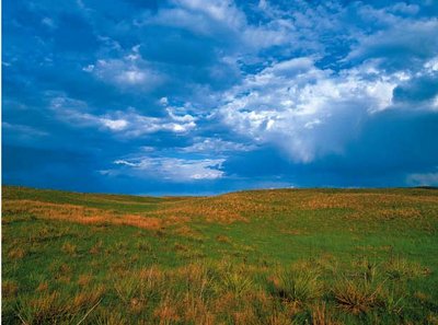
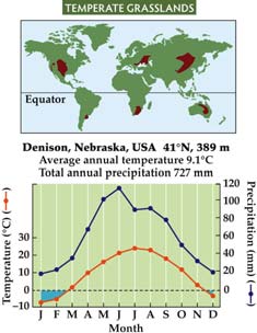
Temperate Grasslands
Characteristics and Distribution
Temperate grasslands are found between 30º and 50º latitude in both hemispheres. They are maintained by fire and grazing, which prevent the establishment of trees and shrubs.
Warm, moist summers and cold, dry winters.
Soils are typically fertile, making these regions important for agriculture (crops and livestock).
Fire and grazing are essential for maintaining grassland structure and biodiversity.
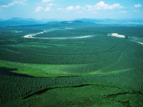
Boreal Forests (Taiga)
Characteristics and Distribution
Boreal forests, or taiga, are found above 50ºN latitude. These forests are dominated by coniferous trees and experience severe winters with subfreezing temperatures and permafrost in some areas.
Soils often freeze, limiting decomposition and nutrient cycling.
Cold air temperatures and short growing seasons.
Primarily composed of conifers such as spruce, fir, and pine.
Tundra
Characteristics and Distribution
Tundra occurs above 65ºN latitude and is characterized by cold temperatures, low precipitation, and permafrost. It differs from cold deserts primarily in latitude and the presence of permafrost.
Vegetation includes low-growing shrubs, forbs, grasses, lichens, and mosses.
Short growing season and limited plant diversity.
Summary Table: Major Terrestrial Biomes
Biome | Latitude | Key Factors | Dominant Vegetation |
|---|---|---|---|
Tropical Rainforest | 10ºN–10ºS | High precipitation, warm, little seasonality | Broadleaf evergreen trees |
Tropical Seasonal Forest/Savanna | 10–23.5º N&S | Seasonal rainfall, fire, grazing | Deciduous trees, grasses |
Desert | ~30º N&S | Low precipitation, high/low temperature | Sparse shrubs, succulents |
Temperate Grassland | 30–50º N&S | Fire, grazing, seasonal temp | Grasses, few trees |
Boreal Forest | >50º N | Cold, severe winters, permafrost | Coniferous trees |
Tundra | >65º N | Cold, low precipitation, permafrost | Mosses, lichens, low shrubs |
Additional Info
Disturbance regimes such as fire and grazing are crucial for maintaining the structure and function of many biomes.
Human activities, including agriculture, logging, and urbanization, are altering biome distributions and ecosystem services.
